

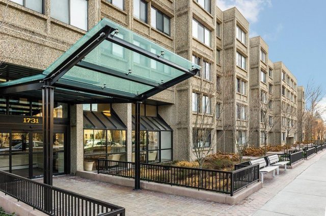
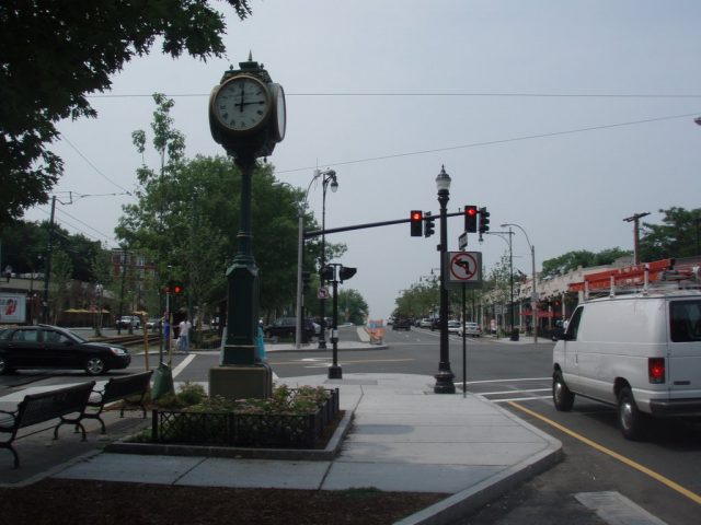
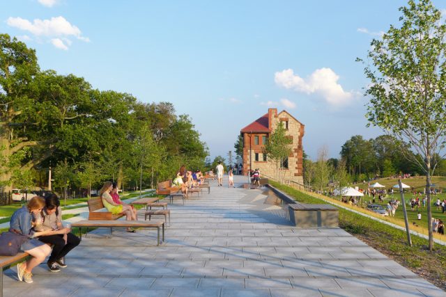
Coolidge Corner
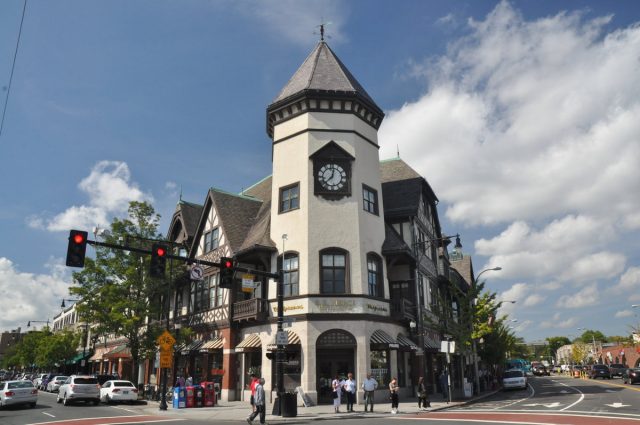
Centered at the intersection of Harvard and Beacon Streets in North Brookline, the Coolidge Corner neighborhood takes its name from a family that operated a general store in the mid-1800s serving the country estates of wealthy Bostonians. The area developed rapidly as a residential and commercial hub following the extension of trolley service from Boston in the late 19th century. Today, the first thing riders on the C-Line notice is the Tudor-style S. S. Pierce Building with its pitched roofs and octagonal clock tower. Built in 1898 as an outpost of the S. S. Pierce grocery business, the building currently houses a Walgreens Pharmacy and a Radio Shack below several stories of offices.
A second building boom between 1920 and 1930 resulted in most of the other area landmarks. Standouts include the Art Deco bank (now a Bank of America branch) diagonally across from the S.S. Pierce Building and the Arcade Building two blocks north on Harvard Street. The Arcade Building features a two-story atrium with a variety of small shops including a comic book store, a salon, several tailors and a take-out restaurant.
Coolidge Corner is the center for shopping in Brookline and has a store for almost everything. While several national retailers have staked out prominent positions in Coolidge Corner, there is still a strong independent spirit, especially shown with the non-profit Coolidge Corner Theatre’s art-house films. The stores range from small boutiques and shops, including Brookline Booksmith, to multiple retail chains, such as Walgreens, Game Stop, Staples, Gap, Radio Shack, Paper Source, and much more. Trader Joes is also available in Coolidge Corner to fulfill any grocery shopping needs.
Getting to Coolidge Corner from Boston is easy: By subway, take the green line, C “Cleveland Circle” train to the Coolidge Corner stop. The #66 bus, from Dudley Station to Harvard Square, runs along Harvard Street, and stops at the Harvard and Beacon Streets intersection. Street parking can be difficult, but there is a metered parking lot directly behind the Arcade Building on Center Street.
Chestnut Hill
The Mall at Chestnut Hill and The Chestnut Hill Shopping Center provide the Chestnut Hill neighborhood with a variety of stores and restaurants. Both shopping centers are located off of Boylston Street, separated by Hammond Pond Parkway. These centers will soon be joined by Chestnut Hill Square, which is currently under construction and will be anchored by Wegmans.
The Chestnut Hill Shopping Center is undergoing a transformation. Opened in 1949, it was by some accounts Massachusetts’ first modern suburban shopping center. A major redevelopment is in the process of expanding the center to more than 400,000-square-feet and adding new retailers.
 When complete, the center will have a contemporary look featuring a new village-like streetscape complete with tree-shaded pedestrian walkways, outdoor dining, cafes and new buildings with glass facades overlooking scenic Hammond Pond. For the first time, storefronts will open to both the south facing Route 9 as well as to the north facing Hammond Pond.
“The design concept transforms a suburban strip retail center into a more active mix of specialty retail stores alongside office and entertainment uses,” states David Chilinski, AIA of Prellwitz Chilinski Associates, the project’s architectural firm. “Site planning reorients Route 9 into an ‘urban’ street lined with shops and linked by multiple pedestrian walkways that function as ‘merchant rows’, alive with sidewalk cafes and retailer’s display windows. This hip new ‘town center’, with its welcoming, comfortable sidewalk experience, will bring a new level of energy, excitement and sophistication to Chestnut Hill.”
Buttonwood Village
Located between Chestnut Hill and Jamaica Plain, Buttonwood Village is an affordable home for young families and professionals. The history of the Village is unknown, however, members of the Brookline Historical Society believe that it was named for the prominent buttons visible on the coats of resident firemen and policemen.
Near to award-winning Brookline public schools, Buttonwood Village is mostly comprised of single family colonial homes from the 1950s. However, according to Street Advisor, there are a few Victorian houses interspersed throughout the area.
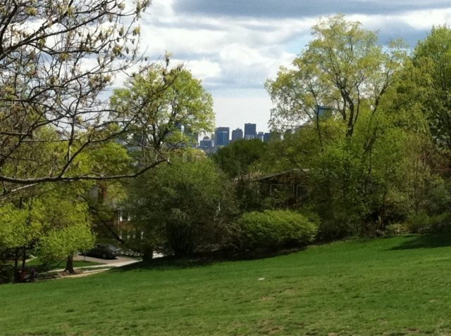
Close in proximity to several recreation areas, Buttonwood Village residents can enjoy nearby Larz Anderson Park, which boasts 64 acres of athletic fields, barbeque and picnic areas, and a skating rink. Skyline views of Boston are visible from several areas of the park, which are popular locations for wedding ceremonies. Another large draw to the Village is the Allendale Farm, which is Boston’s last colonial working farm. Residents and visitors alike can purchase fresh local produce from the market, and enjoy the sight of cows grazing in nearby fields.
Buttonwood Village is accessible by MBTA bus lines, such as the 51 bus to Cleveland Circle via Putterham, or Forest Hills Station via Putterham. The closest stop is Clyde Street, opposite Whitney Street (nearest stop to Larz Anderson Park). However, it is also advised to travel by car.
Brookline Village
Brookline Village captures the quaint small-town feel in the mix of busy city streets. Traditional shops and small restaurants line either side of the street creating a charismatic neighborhood. Brookline Village is full of activity with constant cars and diverse people walking the street, from business people, visitors to Brookline Town Hall, or locals enjoying the neighborhood.
Location: Brookline Village is located at the split of Washington Street and Harvard Street. Washington Street runs off of Boylston Street (Rt. 9) to bring you to the center of Brookline Village. Harvard Street runs from Commonwealth Avenue through Coolidge Corner to Brookline Village.
Description: Brookline Village is rich with history. In the early 1800s, many German and Irish immigrants settled in Brookline Village. In the 1840s, the Linden area, just outside the center of Brookline Village, was created as one of the first developments in Brookline. The area was known as a “garden-suburb,” meaning that the area was for residential homes only, not allowing any other uses, such as manufacturing. Brookline Village contains many historical houses, including the William Bowditch House, located on Toxteth Street off of Linden Place, which served as a house for The Underground Railroad.
Today, Brookline Village maintains its history and keeps the feel of a small town in a big city. A pleasant hubbub of people continually walks throughout Brookline Village. The streets are clean and comfortable with small, cozy shops, neighborhood restaurants, and many offices. A tall black clock stands in the center of the split between Harvard Street and Washington Street and in front of the large “Brookline Village” sign on the side of a building. The clock reads “Francis J. Hickey Triangle,” commemorating Francis J. Hickey, a soldier and community leader of Brookline who devoted his life to bettering Brookline Village and the town of Brookline.
The architecture in Brookline Village matches much of the rest of Brookline, with red brick buildings lining the streets. Local retailers and restaurants reside in the bottom floor of these three and four-story buildings, while the upper-stories provide either offices or apartments. The buildings all have a polished and professional look coordinating with one another. Along the beginning of Harvard Street, most of the shops and restaurants have a similar structure, with wood trim and a green awning displaying the name of the shop or restaurant. Even places such as Dunkin Donuts have their building match this uniformed look for the street.
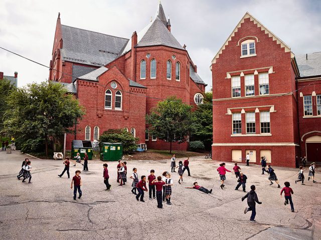
The St. Mary’s of Assumption School, a Catholic school offering pre-k through eighth grade, is located on Harvard Street in the Brookline Village neighborhood. In addition, The Pierce School is also located in Brookline Village, serving as the public school in the neighborhood for pre-k through grade eight.
Within a very short walk to the center of Brookline Village are the Brookline Town Hall and the Public Library of Brookline. The area for the two buildings has beautiful landscaping with green plants and trees creating a very appealing atmosphere around them. Also on Washington Street is the Brookline Public Safety Building, which was originally built as the fire station, and now houses the Brookline Fire Department and the Brookline Police Department.
How to get there: Brookline Village is accessible from many forms of transportation. Brookline Village Station on the “D” branch of the Green Line is located on Station Street, off of Washington Street, and just outside the center of Brookline Village.
Busses 65 and 66 both stop at the Harvard Street at Kent Street bus station in the center of Brookline Village. Further down Harvard Street, also near Brookline Village, is the Harvard Street at Pierce Street bus station, where Bus 66 also stops.
Brookline Village is also driving accessible via Washington Street. Boylston Street, another major road in both Brookline and Boston, runs Southeast of Brookline Village and connects to Washington Street, providing easy access to Brookline Village. There are both street parking and parking lots available.
Places to live: A variety of housing options are available in Brookline Village. Apartments are located above some of the shops and restaurants found on Washington Street. Off of Washington Street, on Davis Avenue, there are also several apartment buildings. In addition, many of the side roads, including Davis Avenue, White Place, and Thayer Street all have residential homes.
Shopping and restaurants: An assortment of shops and restaurants are located in Brookline Village. The restaurants range from small cafes and sandwich shops.
Brookline Village also offers an array of places to shop. There are local book stores, spas, boutiques, and toy stores. There are many services available such as cleaners, jewelers, florist, barbers, and hair salons. A variety of yoga and Pilate studios are also available in Brookline Village.
Aspinwall Hill
Aspinwall Hill is situated between the Corey Hill and Fisher Hill neighborhoods of Brookline and has a rich history, dating back to 1788 when Dr. William Aspinwall purchased the land that would later become known as Aspinwall Hill.
Today, Aspinwall Hill offers both single-family homes and multi-unit homes, including the Beaconsfield Terraces that were built in the 1880s and 1890s and are often referred to as “castle buildings” because of their stained glass windows, rounded turrets, and stonework. Many of the houses that were built during the initial growth of Aspinwall Hill have now been turned into multi-unit dwellings that offer both the convenience of apartment-style living and the architecture of classic Victorian homes. Though housing density is relatively high in Aspinwall Hill the neighborhood does not feel cramped, as the streets are very quiet and offer plenty of greenery and shade.
Aspinwall Hill is conveniently located a short walk from the Washington Square and Beaconsfield T stops on the MBTA green line. Residents of the area enjoy the quiet privacy of the neighborhood as well as the close proximity to the shopping on Beacon Street. This pedestrian-friendly neighborhood also features one of Brookline’s most popular parks, Schick Park, located at the top of the hill.
St. Mary’s
St. Mary’s neighborhood marks an Eastern entrance into Brookline, very close to Boston’s Kenmore Square. St. Mary’s is sandwiched between Boston University and Frederick Law Olmsted’s well known Emerald Necklace, and is within a short walking distance to Simmons College and Emmanuel College. With all the nearby colleges, the streets of St. Mary’s are always populated with college students in addition to the local community. The shops and restaurants of St. Mary’s have stayed at their locations for a long period of time, becoming favorites for the locals.
Location: St. Mary’s is located on Beacon Street, just West of Park Drive. The St. Mary’s neighborhood boarders the edge of Boston and is very close to many of its landmarks, including Fenway Park.
Description: As you transition from Boston to St. Mary’s, you leave the chaos of the large city and quickly acknowledge the difference in the suburban neighborhoods of Brookline. Although St. Mary’s still maintains the city-like atmosphere, simple subtleties mark that you are now in Brookline. More trees and plants give color to the sidewalks and familiar stores line the streets. You feel at ease, and receive the college environment, as you walk the small strip of the St. Mary’s neighborhood.
The architecture of St. Mary’s is much like other neighborhoods in Brookline. The neighborhood alternates between buildings for housing and small stores and restaurants. There are many apartment complexes and townhouses, built mostly of different shades of red and brown brick: hence the name “Brownstones.” The front of these apartments and townhouses have beautiful landscaping, with planted flowers, gardens, bushes, and trees, establishing an enjoyable atmosphere as you walk down the streets of the St. Mary’s neighborhood. The shops and restaurants have a very different look; they are built as smaller square buildings and with much simpler designs.
Also near St. Mary’s, off of the commotion of Beacon Street, is Amory Playground and Halls Pond. Amory Playground provides large open fields, with a baseball diamond, tennis courts, and a lovely area for children to play. Halls Pond is also a charming spot, where you can enjoy peaceful time by the water at a hidden locale in Brookline. Also, in less than a mile, you can find yourself at either the gorgeous Boston Public Gardens or shopping on Newbury Street.
How to get there: Public transportation is easily accessible for St. Mary’s. The “C” Branch of the Green Line runs directly to St. Mary’s. If taking the T from Boston to St. Mary’s, be prepared for the sudden adjustment from dark to light as you exit the 100-year-old underground T, for St. Mary’s is the first above ground T stop. In addition to St. Mary’s Station, neighboring T-stops include Hawes Street and Kent Street.
Although no bus route stops directly in St. Mary’s, there are many nearby stations, including Fenway Station and Park Drive at Beacon Street. Buses 47 and 57 stop at Fenway Station, and bus 47 stops at Park Drive at Beacon Street.
St. Mary’s is also easily accessible via car as Beacon Street is the main road running through St. Mary’s. Park Drive, a major road nearby to St. Mary’s, also provides easy access into the neighborhood.
Parking: Diagonal parking spaces line the train tracks along Beacon Street, providing a significant amount of parking. Parking meters also line both sides of Beacon Street, offering another form of parking for St. Mary’s.
Places to live: St. Mary’s offers a variety of places to live. A vast amount of brownstones, townhouses, and apartment buildings run along Beacon Street. Also, nearby roads off of Beacon Street, such as Carlton Street, Ivy Street, and Chilton Street, provides beautiful single family homes.
Shops and restaurants: Many of the shops and restaurants in St. Mary’s have established themselves as favorites for the locals, as well as the BU students, as the shops and restaurants have held their same location for many years. There are several restaurants, including the Japonaise Bakery for teas and pastries, Taberna de Haro for Spanish tapas, and The Busy Bee for breakfast. The Busy Bee offers great food and has the feel of a classic 1950’s style diner. There are also small restaurants available in St. Mary’s including sandwich shops, sushi, cafes, and pubs, such as Beacon Tavern. The Beacon Tavern offers outdoor seating, providing a great atmosphere for their guests as well as for those walking Beacon Street.
Although it may not be the epicenter for shopping in Brookline, St. Mary’s does offer a great deal of services. There are a number of spas, cleaners, realtors, and banks, including Brookline Bank, available in the St. Mary’s neighborhood. The neighborhood also provides a store for fine wines, a fresh market, and the long standing Economy True Value Hardware store.
Ideal for college students in addition to the locals, St. Mary’s offers a perfect location. There is access to stores, restaurants, and services in the center of St. Mary’s and you are just a short distance from many appealing areas in Boston as well as Brookline.
Washington Square
Washington Square provides a culturally rich neighborhood known for its variety of restaurants and shops. The streets are bustling with a diverse mix of people from the neighborhood, including moms with strollers, business people, college students, and local residents out for a daily run. Washington Square certainly has something for everybody.
Location: Washington Square is located at the intersection of Beacon Street and Washington Street. It marks one of the central neighborhoods of Brookline, with Coolidge Corner to the East, Brookline Village and Pill Hill to the Southeast, and Fisher Hill to the West.
Description: Washington Square flourishes with history. Tappan Street and its surrounding area was once the summer getaway for the wealthy living in Boston. They used the Washington Square neighborhood for their relaxing vacations outside of the city. In addition, Washington Street was one of Brookline’s first roads. The road was used to bring the Brookline’s cattle to the stockyards located in Brighton and Watertown.
Washington Square is situated at the bottom of Aspinwall and Corey Hills, two of Brookline’s largest hills, both great for afternoon picnics.
The neighborhood also includes the Driscoll School, a K-8 public school.
Some of the buildings in Washington Square maintain a historical or Victorian design. However, starkly contrasting, many of the newer structures are quite plain, with very square, simple designs. There are brownstones, new and old apartments and condos, and even a beautiful art deco building on the West-bound side of Beacon Street.
Known for the multitude of shops and restaurants, Washington Square has a vibrant and charming atmosphere. The streets are clean and beautifully landscaped, keeping Washington Square aesthetically appealing. During the day, the neighborhood is busy but comfortable, maintaining a pleasant hubbub of people and activity. At night, when the weather cooperates, Washington Square really comes alive, as the neighborhood is filled with people dining at the various restaurants or simply enjoying an evening stroll. Washington Square keeps the city atmosphere while maintaining a sense of community.
How to get there: Washington Square is easily accessible via many means of transportation. The MBTA’s T subway system, specifically the Green Line “C” branch, runs directly through Washington Square. The best stop to get off is Washington Square Station on Beacon Street, depositing you in the heart of Washington Square. Additional nearby stops include Fairbanks Street, Tappan Street, and Dean Road Stations.
Bus 65 also allows easy access to Washington Square. (Bus 65 – Brighton Center – Kenmore Sta. via Washington Street, Brookline Village & Brookline Avenue).
By car, both Washington Street and Beacon Street provide easy access to Washington Square.
Parking: Parking is sometimes hard to come by, but there are still plenty of options. Although there are no parking lots in Washington Square, the nearby station Beaconfield T station provides a small lot. In addition, a great deal of metered parking spaces line the train tracks up Beacon Street. There are also many parking meters located along the sides of the road on Beacon Street and Washington Street.
Places to live: A variety of housing is also available in Washington Square. Beautiful single family homes inhabit the surrounding streets off of Washington Street and Beacon Street. The streets present perfect neighborhoods and locations for families, with several nearby parks, including Griggs Park and Schick Park, as well as Driscoll School, which has a field, basketball courts, and two tennis courts.
Washington Square includes a great deal of brownstones and apartment complexes. Apartment complexes can be found directly in the center of Washington Square on both Washington and Beacon Streets, or also more privately tucked away on side streets. Washington Square’s largest condo complex, Washington on the Square, provides multiple studio, 1 and 2 bedroom condos.
Shops and restaurants: When walking the neighborhood for Washington Square shopping, you can find a shop for almost anything you need. Services range from dry cleaners, shoe repair, multiple hair and nail salons, to the Cambridge Eye Doctor. Shops are located along Washington Street and Beacon Street to provide you with whatever goods you need, including your old-fashioned hardware store, sports-needs store, home and garden store, convenient stores, and of course, lots of banks and ATMs, including Brookline Bank.
In addition to the surplus of shopping available in Washington Square, the neighborhood has a large selection of restaurants. For whatever flavors your taste buds desire, Washington Square has a restaurant to satisfy any craving, including Thai, Chinese, Italian, Japanese, and American Grill. Over the last couple of years, many of the restaurants in Washington Square have added outdoor seating including The Golden Temple, The Abbey, The Fireplace, and Washington Square Tavern. The Abbey offers a varied menu for lunch, dinner, drinks, or late night. Small cafes and bakeries line the streets, allowing you to grab a coffee to-go or stay and enjoy a relaxing lunch. There is even an Emack and Bolio’s ice-cream and Athan’s Bakery to satisfy that sweet tooth.
If you are looking for provisions to take home with you, Washington Square can still cater to your needs. The neighborhood includes a large supermarket as well as a nearby Whole-Foods market, in addition to a liquor store and store dedicated to fine wines.
The shops, the restaurants, the people; they all bring life to Washington Square. The large number of outdoor seats has created a “mini-Newbury Street” feel to Washington Square. With the nightly crowd of people dining outside and enjoying warm summer nights on the street, Washington Square establishes itself as a neighborhood of elegance and comfort.
JFK Crossing
JFK Crossing blends the qualities of an urban and suburban neighborhood. The street is lined with shops and restaurants and busy with a constant flow of people. Yet, JFK Crossing also maintains the comfort of a community with many residential homes. The neighborhood has a flourishing Jewish population with several Jewish themed stores, markets and kosher restaurants.
Location: JFK Crossing is located on Harvard Street between Naples Street and Verndale Street. JFK Crossing is very close to Coolidge Corner, just a short distance traveling northwest on Harvard Street from the Coolidge Corner center.
Description: JFK Crossing receives its name from our 35th president, John Fitzgerald Kennedy. Kennedy grew up in Brookline and was born just around the corner at 83 Beals Street. Kennedy attended the Devotion School, one of the public elementary schools in Brookline. Today, the school and community honor their history and President Kennedy; each year the 3rd grade class at the Devotion School does a 4-week study on President Kennedy and commemorates him by writing poems and essays on what JFK Crossing means to them.
After the assassination of President Kennedy in 1963, his mother, Rose Fitzgerald Kennedy, returned to their home on Beals Street and restored the house to its original look at Kennedy’s birth in 1917. 83 Beals Street is now a National Historic Site and offers tours of the house and neighborhood, allowing people to stay connected with the history of our 35th President.
To commemorate former President Kennedy in your own home, visit iCanvasArt.
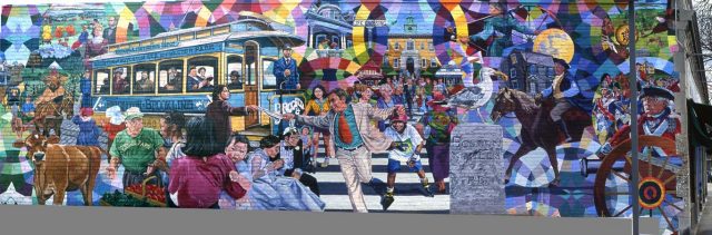
JFK Crossing mixes both an urban and suburban feel to the neighborhood. Harvard Street is busy with shops and restaurants, keeping the street full of activity and people. Most of the buildings in the JFK neighborhood are made of old brick and stone. Also incorporated in the neighborhood are a series of four hand-painted murals honoring the rich history surrounding JFK Crossing. The murals incorporate bright colors and immense detailing, each telling a different story with its imagery. The murals not only provide aesthetically appealing artwork, but they give JFK Crossing character. Also, there are many characteristics denoting the Jewish legacy at JFK Crossing, including several kosher restaurants, signs written in Hebrew, an Israel Book Shop, and a sign that reads “Kosher Kitchen Headquarters.”
Contrasting the business of Harvard Street, the side streets that run off of the main road provide quaint residential areas. Rows of thick trees run in front of the houses, creating a canopy of leaves over the houses and streets. The residential neighborhoods in JFK Crossing bring you to a calmer location and a peaceful suburban atmosphere.
How to get there: JFK Crossing is accessible from all forms of transportation. Although there is no T stop directly in the neighborhood, the Coolidge Corner Station stop on the Green Line “C” branch is only a ten minute walk from JFK Crossing.
Bus 66 (Harvard Square via Allston) also has stops located in the center of JFK Crossing. Both stops Harvard Street at Coolidge Street and Harvard Street at Beals Street deposit you directly in JFK Crossing.
JFK Crossing can also be easily reached via car. Harvard Street stretches south to Washington Street and Northwest to Brighton Ave and Cambridge Street.
Parking: A great deal of meter parking is available in JFK Crossing located on both sides of Harvard Street.
Places to live: JFK Crossing offers mainly residential living with few apartment complexes. The side roads off of Harvard Street provide wonderful neighborhoods filled with single-family homes. The neighborhoods offer perfect residential areas setback from the commotion on Harvard Street.
Shopping and restaurants: JFK Crossing has a wide variety of choices for restaurants offering foods from around the world. The Cognac Bistro brings you to France providing a classic brasserie and fantastic food. You can have the option of either Chinese food at Taam China, or Japanese food and outstanding sushi at Genki Ya. The Daily Catch offers fresh seafood, Dok Bua serves delicious Thai foods, and the Pita Pit provides tasty and healthy wraps on their specialty Lebanese-style pitas. Wings Over Brookline satisfies the craving for American favorites of wings and ribs. JFK Crossing also has bakeries and coffee shops, including the local’s favorite Kupel’s Bakery as well as the national chain Starbucks.
JFK Crossing also provides a great deal of shops and services. The neighborhood includes many national chains such as True Value Hardware Store and Massage Envy. However, there are also many independently owned craft stores and shops, such as the Israel Book Store. There are also many nail and hair salons, dry cleaners, and of course, a multitude of banks. Also, The Butcherie is a unique store to JFK Crossing, providing an entirely kosher grocery store making shopping efficient for the Jewish community that keeps kosher.
South Brookline
Characterized by rolling green hills and grand estates, South Brookline is one of the few truly open spaces left outside of Boston. The first residents of South Brookline were farm owners, and many of the properties are still very large as a result of conservation laws that prevented further development. As a result, South Brookline still retains much of its original charm.
Homes were originally made of wood, with simple styles that reflected the relaxed, simplistic manner of their residents. However, with the increase of European influence in newspapers and other books, home-owners began to construct bigger homes out of granite and brick, believing their residences and gardens were manifestations of their wealth (Brookline Historical Society).
Brookline Historical Society believes that one of South Brookline’s first residents, John Goddard, was instrumental in the Revolutionary War because he kept military supplies in his barn and later distributed them to New England soldiers. Many South Brookline estates later became home to several wealthy and famous residents, such as the Sargent Estate, which was home to Charles Sargent, the first director of the Arnold Arboretum, as well as several other landscapers and architects. Today, it is rumored that football star Tom Brady and Gisele Bundchen live there as well.
In 1882, the first country club also opened in nearby Clyde Park. Named The Country Club, it first began as a horseracing club, but later sought to combine social gatherings and sports in the form of golf and other leisure activities.
Today, South Brookline is a popular home for professionals with children, due to its close proximity to Boston and Brookline public schools. However, originally built to house soldiers in World War II, the John Hancock apartment buildings do provide multi-family residences. South Brookline is accessible by MBTA bus lines and commuter rail; however it is also advisable to travel by car.
Griggs Park
Located between the busy streets of Beacon Street and Washington Street, Griggs Park gives its residents the feeling of living in the country, but with a city skyline off in the distance.
At the center of Griggs Park is Griggs Field, a 4.17-acre oasis that was once a wetland and now is home to weeping willows, a small pond, and walking paths. Residents of Griggs Park get to enjoy this natural landscape while still having the convenience of being located right off the Fairbanks Street and Washington Street stops on the MBTA green line. “The Friends of Griggs Park” is a volunteer group founded by the areas residents that is dedicated to helping maintain the park area with regular clean-ups and planting of new greenery.
Housing in Griggs Park offers a mix of single-family dwellings and multi-family dwellings and the density is relatively low compared to surrounding areas. The area of Griggs Park is part of the National Register of Historic places and it was founded in 1903 when Thomas B. Griggs began to develop residential properties surrounding the wetland.
Fisher Hill
Some of the largest and most expensive estates lie within the boundaries of Fisher Hill, an upscale neighborhood located next to the Fisher Hill Reservoir. The neighborhood is named after Francis Fisher who built his estate on the corner of Boylston Street and Chestnut Hill Avenue in 1852. It is also known as Brookline Hill, Mount Vernon, and Henshaw Hill.
Fisher Hill is one of the more secluded neighborhoods of the Brookline area. Its streets are lined with tall shady trees and its homes are picturesque. Fisher Hill started growing in the early 1800s when wealthy families wanted to build convenient yet rural estates to live in during the summer months. The area today is still residential and offers the same quiet respite from the busy streets of Boston for which it was originally popular.
In 1984 Fisher Hill was named a National Register Historic District. The neighborhood is home to many houses that were built in the early 1800s, and due largely to efforts by some of its first residents, the majority of these homes are still single-family dwellings that have not been turned into apartment complexes. Fisher Hill is located near the Chestnut Hill Ave and Reservoir stops on the MBTA green line.
Cottage Farm
Located between Carlton Street and St. Paul Street, Cottage Farm is a residential neighborhood of 119 acres. Originally, the area belonged to David Sears II, who purchased the land in 1820. Sears designed the homes similar to English cottages, and modeled them in Gothic Revival and Queen Anne styles. Most of the houses were also built behind private grass squares, which Sears designed for the residents to enjoy. The squares later became public property in the 1920s, and are now home to playgrounds and recreation areas. The land was then sold in the 1850s to Amos Lawrence, a wealthy cotton businessman, who thought Cottage Farm homes perfect for those who were working in Boston, but still wanted a rural lifestyle.
As said by Brookline Historical Society, residents today can enjoy Sears’ ideal of a “gracious, comfortable home in a rural setting.” Close to Boston University, the area is home to some students, but still has the charm of the 1850s. Just a short walk down Amory Street and the sounds of the city quickly melt away. Further on Amory are the Amory Woods and Hall’s Pond Sanctuary, a habitat for a variety of plants and animals. The sanctuary also has one of the last two natural ponds remaining in Brookline.
Cottage Farm is accessible by the Green Line towards Boston College at the Babcock Street or St. Paul Street stops, as well as the 57 bus to Amory Street.
Corey Hill
Named after Timothy Corey, who settled on the hill in 1760, Corey Hill is often referred to as “The Great Hill” because it sits 260 feet above sea level. This area of Brookline is located off of Washington Square, just a short T ride on the “C” branch of the MBTA Green Line to Coolidge Corner, a small shopping center that offers a wide variety of shops, restaurants, and services, many of which are locally owned.
Corey Hill lays claim to one of the best views that the greater Boston area has to offer. Once at the apex of Summit Avenue, you will find yourself in a quaint and quiet park that serves as a sanctuary to Brookline residents and visitors alike. Its residents cherish the Corey Hill Outlook as a great place to bring your family to escape the hustle and bustle of the city and enjoy some green space. The paths that traverse Corey Hill are special to the neighborhood because not only do they provide quiet walking paths to its residents, they are often a more direct route than the streets and can be useful to pedestrians.
Putterham
Putterham provides a small, quiet neighborhood in the more suburban area of Brookline. Unlike many of the neighborhoods in Brookline that center primarily around shopping and dining, Putterham has a calmer atmosphere. Putterham shows a different side of Brookline, with a dozen-plus shops in a single strip mall set amongst single family homes.
Location: Putterham is located between South Brookline and Chestnut Hill, at the intersection of Grove Street and West Roxbury Parkway. The intersection of the two streets creates a small rotary, marking the Putterham neighborhood.
Description: Putterham marks its place in history with the Putterham School, a single-room school house that dates back to over 200 years ago. The school house was built on Grove Street in 1768 and provided children a place for education throughout many years of history. Recognized as an historic site, in 1966 the Putterham School was moved to Larz Anderson Park, where it still remains today.
Today, Putterham is known for its two golf courses, the public Robert T. Lynch at Putterham Meadows and a very exclusive private course, The Country Club. The Country Club hosts many world famous golf tournaments, including the 2013 US Amateur, the 1995 Women’s US Amateur, and the 1988 US Open. The golf course at Putterham Meadows is a beautiful 18-hole public course. In addition, be sure to stop by The Vine Ripe Grille, a lovely restaurant overlooking the course.
The Putterham neighborhood has a very serene environment, located far enough away from the commotion in the center of Brookline, yet still easily accessible. The small neighborhood has a single strip mall, The Shops at Putterham, located in the center of residential homes. The Shops at Putterham and many of the surrounding homes are constructed of red brick, with accents of white siding. The landscaping outside The Shops at Putterham is gorgeous. The bright green grass is contrasted with vibrantly colored flowers and planted shrubbery. A row of small trees lines the front side of the building, matching the nature surrounding the small shopping center and blending into the quiet atmosphere.
Temple Emeth is located across from The Shops at Putterham. The temple builds off of the beauty and simplicity found at Putterham, with green vines weaving and growing up the side of the building. Also near Putterham is the Walnut Hills Cemetery, Brookline’s second oldest burial grounds.
Also, nearby Putterham is the Baker School, one of Brookline’s K-grade 8 public elementary schools. The school also provides Baker Park, a beautiful location to bring children to play, including a large open field with a baseball diamond and soccer field.
How to get there: The West Roxbury Parkway and Grove Street connect to many main roads in Brookline, allowing direct and easy routes to Putterham via car.
Bus 51 (Cleveland Circle – Forest Hills Stations via Hancock Street) also provides easy access to Putterham, making stops at Grove Street at South Street, as well as nearby station 145 Grove Street opp. Bellingham Road.
Although there is no T station directly in the Putterham neighborhood, Putterham is accessible by taking the Green Line “C” branch to Cleveland Circle then taking Bus 51 from the Cleveland Circle Station to Grove Street.
Parking: The parking lot located at The Shops at Putterham provides a great deal of easy parking to accommodate anyone visiting the shops and restaurants.
Places to live: Putterham is mainly a residential neighborhood. Beautiful single-family homes line the multiple small streets throughout Putterham, creating perfect neighborhoods for families.
Shops and restaurants: The Shops at Putterham provide the Putterham neighborhood with several independently owned shops and restaurants as well as national chains, such as Starbucks. Many of the small restaurants have established themselves as favorites for the locals. The Mandarin Gourmet serves delicious Chinese food while the Putterham Grille specializes in American and Greek cuisine. In addition, Cheryl Ann’s Bakery offers everything you could ask for from a bakery, including breads, cookies, and cupcakes.
There are also a number of services and shops available at Putterham. The Shops at Putterham include a florists, dry cleaners, nail and hair salon, custom framing, stationary store, and bank. The Grove Street Market also provides any necessary groceries, as well as a selection of beers and wines.
Pill Hill
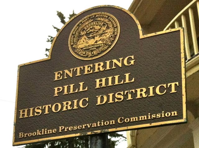
Pill Hill is a residential neighborhood that got its name because of its close proximity to the Longwood Medical Center and its high population of doctors and hospital employees. The Pill Hill Local Historic District is in the southeast section of Brookline, just a few minutes walk to the Brookline Village T stop on the MBTA Green line. It borders Frederick Law Olmstead’s infamous Emerald Necklace, Boylston Street, Brookline Village, and Oakland Road.
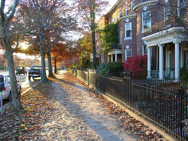
The majority of houses in the area were built between 1870 and 1930, and the neighborhood is home to some beautiful examples of Victorian, English Cottage, Colonial Revival, Mansard and Greek Revival architecture, including stick and shingle style edifices. The streets of High Street Hill boast beautiful views and serve as a quiet respite from the busy streets of Boston for its residents.
Much of the landscaping around these homes is inspired by Olmsted himself such as the Charles Storrow House and the Philbrick Estate. Many of the homes sit harmoniously on winding roads, although each representing a unique character that is well maintained with historical accuracy.
The area not only holds the historic architecture and landscaping in high regard, but it also prizes itself on the intellectual circles that first resided there and still do today. Pill Hill was home to one of the area’s first women’s hospitals, The Free Hospital for Women, which has been located on Pill Hill since 1895. This hospital was the first to use radiation therapy on cancer patients.
North Brookline
Known as “the most densely populated area of Brookline,” the Brookline Historical Society describes North Brookline as the ultimate mix between suburban and urban living. Prior to 1768, North Brookline’s Harvard Avenue was the primary path to Cambridge from Boston until the building of the Charles River Bridge in 1786.
Before the trolley began to run in 1880, North Brookline was largely a swamp and farming community, with few houses scattered along dirt roads. However, the construction of the trolley brought large groups of Irish and Jewish settlers to the area.
One of the most popular draws for North Brookline is the John F. Kennedy Historical Site at 83 Beals Street, which is where the former president was born. After spending several of his childhood years there, Kennedy later moved to another home in Boston. However, the old-style home still remains as a free museum.
Currently, North Brookline has a mix of historic homes and apartment buildings. Despite its dense population, one only has to step off of busy Harvard Avenue onto one of the side streets, and the crowds begin to disperse. A mix of college students and families means that there are many affordable restaurants in the area.
North Brookline is accessible on the B and C Green lines and is close to Winthrop Square. It can also be reached on the 57 bus via Watertown Yard to Babcock Street.
Longwood
The Longwood neighborhood is the furthest east of Brookline and therefore the closest in proximity to the city of Boston. It was named after Napoleon’s estate on St. Helena by David Sears II. Sears was one of the wealthiest landowners in Boston during his lifetime and purchased land in Brookline in the 1820s in hopes of developing it.
The Longwood area houses part of Wheelock College, yet it is a quiet area that attracts an older professional demographic and few students. There are four well-known squares in the Longwood area – Kynvet, Longwood, Mason, and Winthrop – that originated out of the initial “English Cottages” style that many of the first homes of Longwood were built in. These homes were designed in the style of Greek revival architecture and instead of being arranged in a strict grid pattern they were built around residential squares. This planning style created the current aesthetics of Longwood that features urban residential areas surrounding public green areas for residents to enjoy.
The ”D” Branch of the MBTA green line runs through Longwood, and the neighborhood has its own “Longwood” stop, as well as a nearby stop on the “C” Branch called Hawes Street. Longwood is in close proximity to the heart of Boston, so the neighborhood does not offer many restaurants and shops of its own. The area is primarily residential and very quiet, and its residents can head to the Fenway area if they are looking for shopping or a fun night scene.
Мистерията на символа @ в български превод от 1345 година
Маймунското “а” символизира интернет ерата, той е от съществено значение за изпращането на имейли и за социалните мрежи. Но едва ли много хора са запознати с произхода му.
Кльомбата някога е била слабо познат символ, известен само на деловодителите. Този факт се променя, благодарение на Рей Томлинсън, смятан за откривател на електронната поща.
През 1971 той поставил символа между потребителското име и адреса докато се опитвал да изпрати съобщение между два компютъра. Томлинсън избрал @, защото по онова време той рядко се използвал в света на компютрите и не би предизвикал объркване сред ранните операционни системи и програми.
Маймунското “а” се появи върху пишещите машини преди края на 19-ти век и обозначава умножението на броя предмети по цената им. По онова време това било единственото му значение.
По-късно се появява и върху компютърните клавиатури.
Причината е, че кльомбата в основата се е смятана за бизнес символ и се използва в бизнес средите.
През 2000 година италианският академик Джорджио Стабиле открива, че различните държави са дали различно наименование на символа @. Турците го наричат “роза”, норвежците “свинска опашка”, гърците “пате”, а унгарците – “червей”.
На френски, испански и португалски символът е известен като arobase или arroba – единица за тегло и стойност. Италианското наименование на символа е амфора, по подобие на древните съдове за съхранение.
Стабиле открил писмо, изпратено от Севиля до Рим през 1536 година, в което се обсъждало пристигането в Испания на три кораба от Новия свят. В писмото била описана продажбата на една амфора пълна с вино, но името на съда било заменено със символа @ за по-кратко. Стабиле заключил, че кльомбата е средновековен способ за стенографиране на различни мерни единици в Южна Европа.
Испанският журналист Хорхе Романс открил доказателства дори за по-ранна употреба на символа. “Спомням си, че попаднах на него като студент по история в Университета в Сарагоса, открих го в митнически документи между Арагон и Кастиля през 15-ти век. Означаваше ‘arroba’ – мерна единица за тегло – в този случай една arroba пшеница.”
Още по-ранни свидетелства подсказват религиозната употреба на символа @. Той се появява в български превод на гръцки хроники от 1345 година. Съхранявани днес в Апостолическата библиотека на Ватиката, хрониките се отличават с употребата на символа @ вместо буквата “А” в думата “Амин”. Защо кльомбата е била използвана в този контекст остава мистерия и до днес.
Важното е, че когато Томлинсън изпратил първото съобщение до tomlinson@bbn.tenexa, той едва ли е осъзнавал как това ще промени хода на събитията.
Rummy
[cardgame title=vegas-three-card-rummy id=56]
Sic bo
[cardgame title=sic-bo id=1026]
Шах
[cardgame title=pink-panther-scratch id=994]
Bowling
[cardgame title=bonus-bowling id=1105]
Crown & anchor
[cardgame title=crown-and-anchor id=780]
Stravaganza
[cardgame title=stravaganza id=1022]
Wild viking
[cardgame title=wild-viking id=1006]
Triple pocket hold’em
[cardgame title=triple-pocket-holdem-poker id=508]
Spingo
[cardgame title=spingo id=553]
Odd one in
[cardgame title=odd-one-in id=106]
Scratch cards
[cardgame title=the-avengers-scratch id=312]
Heads or tails
[cardgame title=heads-or-tails id=1061]
† Днес почитаме Свети Антоний Велики
На 17 януари празнуваме Антоновден, почита се паметта на Свети Антоний. На този ден празнуват имен ден Антон и Антония, Тони, Тончо, Дончо, Донка, Антоанета и Андон.
Свети Антоний Велики бил роден в богато семейство, но като младеж останал сирак. Вместо да продължи занаята на баща си, който му оставил доста пари, свети Антоний раздал всичко, което имал, на бедните.
След това той се усамотил в една пещера. В пещерата свети Антоний бил нападнат от хищници, но от небето се разляла светлина, която премахнала многобройните му рани.
От небето се чул глас, който казал на свети Антоний, че ще стане известен по целия свят. Тогава свети Антоний се зазидал в стара къща, където живял сам десетки години.
ой починал на 17 януари, затова на този ден се почита паметта му. Свети Антоний наистина станал известен със способността си да лекува неизлечимо болните, след като излязъл от зазидания си дом.
Тъй като светецът е известен с лечителската си дарба, този ден се свързва с болестите и по-точно с различниритуали за предпазване от тях. Едно време са се правили питки на този ден, които са се мазали с мед и са се давали на децата.
И досега в някои райони на България този обичай се спазва, за да са здрави децата, а и възрастните. Тъй като свети Антоний се смята за защитник на българите от чума, на този ден задължително се правела питка, която не се дарявала на никого и никой не хапвал от нея.
Тя се оставяла, за да се нахрани с нея чумата и да не закача никого от семейството. Тъй като от суеверие хората не са изричали думата „чума”, тя била известна като „леля”.
На Антоновден много неща са забранени, именно за да не се разгневи чумата. На жените е било забранено да предат, да тъкат и да плетат, както и да варят боб.


